Another seawall wasn’t the answer. Even if the design team merely wanted to rebuild the 50-year-old sheet-pile wall to protect the Massachusetts Bay Transportation Authority’s largest bus maintenance facility, doing so would require relocating two large transmission lines running behind the existing bulkhead or cantilevering the wall. And a new Charlestown wall on the tidally influenced Mystic River likely would need replacing in another 50 years, says Paul Schuman, a senior staffer for the project’s lead engineering firm, Simpson Gumpertz & Heger.
 “Building a new wall is often the typical choice in these situations,” Schuman says. “Our choice was driven by the replacement cost of the steel wall in the future.”
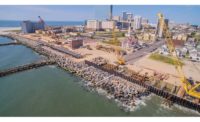
Instead, the $34-million project will include a 40-ft-wide embankment built into the water to buttress the existing 1,200-ft-long wall. Beginning in August, the two-year project will also include a stone revetment to protect another 800 ft of shoreline in neighboring Somerville, Mass. Landscaping above the high-water elevation will create a “living shoreline,” providing a more natural, gradual and resilient sea barrier than a sharp bulkhead. New drainage systems with backflow protections will guard against storm surges. And a multiuse bike path will be built on top of the embankment, which will be wide enough for the construction of an additional wall to guard against future sea-level rise.
The 18-ft-tall embankment was designed to be about 2 ft higher than the existing wall to combat midcentury sea-level-rise projections, “even during a hypothetical 1,000-year storm at high tide,” says Marybeth Riley-Gilbert, a climate resiliency specialist for the MBTA.
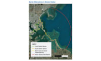
Given that Boston is projected to experience between 2 ft and 6 ft of sea-level rise by the end of the century, the Charlestown embankment is just one of several resiliency projects being considered in the region. While several small projects such as the Charlestown seawall are in the works, the University of Massachusetts Boston currently is studying the feasibility of a 4-mile-long seawall to enclose Boston Harbor. The recently released “Climate-Ready Boston” study takes a regional approach to sea-level rise by collaborating with the Massachusetts Office of Coastal Zone Management. The plan also deploys neighborhood-level solutions to rising tides.
Charlestown is one such seaside community. Its bus facility houses and maintains 230 buses that serve nearly 100,000 riders daily. But the facility’s seawall is riddled with holes, allowing soil to migrate into the river, and corroding sheet metal and drainage pipes contribute to large sinkholes and localized flooding. The eroding shoreline has even encroached on a bus circulation lane. With an estimated $600-million price tag to replace the facility, Riley-Gilbert says it’s “critical” for it to “remain operational.”
The unstable soils will be shored up by more than 2,300 soilcrete columns. Designed to be a minimum of 4 ft in dia, the columns will be driven 25 ft below grade, on average. The soilcrete base will support a 1,500-ft-long by 40-ft-wide relieving platform, composed of interlocking stone and geogrid 2 ft to 3 ft thick.
In this case, the project will mitigate environmental impacts by creating a 11,800-sq-ft tidal beach. Further, the MBTA has proposed contributing nearly $1 million to a Massachusetts program to provide in-lieu fee compensatory mitigation for use on other projects.


Post a comment to this article
Report Abusive Comment