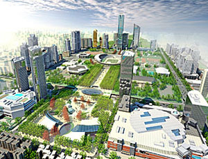
With three projects under construction and three more scheduled to start by the end of the year, officials in Guangzhou, China, are spending nearly $1 billion to prepare the north axis of the city’s center for the 16th Asian Games, which begin on Nov. 12, 2010. Although near-term activity is focused on improving the north axis, which covers 5.9 sq kilometers, the city has even more ambitious long-term plans, valued at $6.5 billion worth of construction, for the adjacent 16.1-sq-kilometer area, called the south axis.
“This place is wild” with activity, says Jeffrey Heller, president of Heller Manus Architects. The San Francisco-based architect is the lead planner for both city districts. It won a competition for the south axis master plan in September, with the San Francisco office of landscape architect SWA Group, AECOM Transportation, Oakland, Calif., and Shanghai Concept Engineering Consulting, the team’s Chinese associate. The team for the north axis master plan, with architectural interventions, which Heller Manus landed five years ago, also includes Seattle-based architect Callison and Simon & Associates, a San Francisco-based sustainability consultant.
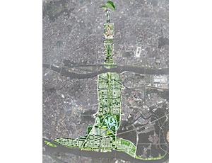
The so-called downtown axis, including both the north and south sections, is 11 km long. It begins at the main railway station to the north and terminates at the Pearl River to the south. One project under way within the north axis is the Tianhe Sports Center Plaza, which involves landscape design for the existing three-stadium sports center, underground parking for 3,000 vehicles and 50,000 sq m of underground retail. Demolition work and landscaping also is under way for Hongcheng Plaza, which will be built after the Asian Games. Plans call for a 40,000-sq-m open-air plaza, 5,000 sq m of retail above ground and 40,000 sq m below ground, and 500 underground parking spaces. Work is under way on a new pedestrian bridge to Haixinsha Island, as well as landscape design for the island, a waterfront amphitheater and some small retail spaces. Projects expected to get under way by the end of the year involve the East Railway Station improvements, preservation of and improvements to the existing 6 Yun Neighborhood and the Huangpu Road Sky Bridge.
Heller says the south axis plan, which contains projects that will take years to realize, is likely to be complete by the middle of next year. The plan includes waterfront and transit-oriented development with a ferry terminal, multimodal transportation facilities and various urban land uses, including a central park. Heller says its plan was chosen over two others because of its approach to balancing growth with sustainability and preservation. The plan also integrates the traditional Lingnan culture.
A primary goal is to satisfy the growing transportation demand of the 10-million Guangzhou residents and future residents in the new town area using green transportation planning principles and an emphasis of nontraditional transportation modes, says Jeffrey Chan, AECOM’s senior transportation planner and project manager.
As the region industrialized, water-based transportation was used solely for the movement of goods, says Chan. Passenger transportation dwindled and gave way to roadway construction, he adds.
The new plan establishes and develops a comprehensive water-taxi system and greatly expands the very limited ferry-route system. Ferries would be used to complement and connect the light-rail and multimodal transit hubs, which would have high-density developments. “I introduced the concept of light rail in Guangzhou,” says Heller.
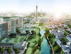
The heart of the south axis would be a 2.6-km-long park, divided into seven segments by crossing streets. “We are proposing three different types of park spaces along the length from north to south,” tied together by a continuous water element, says Rene Bihan, SWA’s managing principal.
In one section, an existing drainage canal would be turned into a naturalized waterway that is a functioning stormwater stream capable of mitigating flood conditions through an overflow basin at its edges while providing a public-use piece of nature that introduces the “ecopark” and a flood-control lake, says Bihan.
The team is hoping its plan will become a model for sustainability, livability and growth not only for Guangzhou but for other Chinese cities as well.


Post a comment to this article
Report Abusive Comment