Hurricane Matthew’s rampage through the Caribbean, the Bahamas and up the southeast U.S. coast tested storm and flood forecasters, utilities, contractor preparations and civil engineering works for more than 1,500 miles and, in some cases, found them wanting.
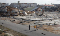
Reports are trickling in from the western arm of Haiti, where Matthew first made landfall on Oct. 4, with 145-mph winds and a surge that knocked out communications and bridges. Reportedly, it killed 1,000 people and left 1.4 million at risk of diseases and food and water shortages.
The situation prompted the United Nations Children’s Fund on Oct. 10 to warn of the threat of waterborne diseases to children in the worst-affected areas. It launched a $120-million relief appeal. “Some towns and villages have been almost wiped off the map,” said U.N. Secretary General Ban Ki-Moon at a press conference in New York City. “Crops and food reserves have been destroyed. At least 300 schools have been damaged.”
The U.S. Agency for International Development’s office of foreign disaster assistance has committed $1.5 million in aid and is shipping relief to Haiti and the Bahamas.
In Haiti, Mark Broughton, an engineer and associate with Miyamoto International, on Oct. 7 traveled into the disaster zone with engineers from Proximité Catholique avec Haiti et son Eglise, who assessed the damage to churches and cathedrals. Miyamoto International is a global engineering and construction management firm providing services to help localities protect themselves and recover from natural disasters.
Broughton says the engineers began to see heavy wind damage at Léogâne, about 42 kilometers west of Port au Prince on Route 2. They forded a river at the first washed-out bridge at Petit-Goâve, about the same distance farther along. “We started to see the first signs of property damage, roads, buildings, churches and other structures all around Miragoâne,” he reports. The team visited six churches and a cathedral in Le Cayes and found heavy damage to all. They made it as far as Camp-Perrin and report finding increasingly shocking damage and some areas impassable.
The death toll in the U.S. climbed to 24 by Oct. 11, with 15 of those fatalities in North Carolina, where southeastern inland areas were hit by record floods, triggered by torrential rains and the storm surge’s push into estuaries and rivers.
Electric utilities were hit hard, particularly in Georgia and the Carolinas. “Hurricane Matthew has left large portions of the Carolinas more heavily damaged than projected, on a scale similar to the destruction of Hurricanes Hugo and Floyd. In some service areas the electrical system will need to be rebuilt,” reported Duke Energy in a statement. The utility had 660,000 outages in the Carolinas.
Georgia Power officials said Matthew was the strongest storm to hit the region in a century, interrupting service to more than 340,000 customers. It reports more than 500 damaged or broken distribution poles and nearly 38 miles of wire needing replacement.
In Florida, seas undermined a 1.3-mile-long stretch of state Route A1A in Flagler Beach, collapsing parts of the highway. Florida Dept. of Transportation officials estimate reconstruction could cost up to $35 million.
The design would be modeled on a 150-ft-long section of the road that survived. After a storm 10 years ago, FDOT armored the road in one place by installing sheet piling capped by asphalt. Other sections were bolstered with granite and coquina boulders, says Noranne Downs, FDOT’s District 5 secretary. “That didn’t work,” Downs says. “The boulders are all over the place.”
U.S. Rep. John L. Mica (R-Fla.), who represents the area, says the repairs will be expedited, saying, “We have a model that just survived a bad hit, and it’s my guess that they go with that or something that can resolve this, long term. There’s no real short-term fix. You’ve got to secure the highway—there’s just no way around it.”
Downs says repairs could get started in a few weeks, perhaps with upgrades such as cathodic protection, thicker steel and enhanced tie-backs “to engineer and construct something to last for 50 years.”
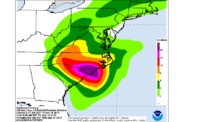
As Matthew neared the U.S., forecasters and emergency managers used data from a National Weather Service graphical tool, called Tropical Cyclone Storm Surge Probabilities (P-Surge), to spot areas most likely to experience storm surge.
Developed by the NWS’ Meteorological Development Laboratory and the National Hurricane Center, P-Surge statistically evaluates multiple runs of the agency’s historical storm-surge prediction model for specific areas, given their topographic and bathrythmic data. Each model run takes into account the storm’s track, size and intensity, as well as the timing of astronomical tides.
Brian Zachry, a storm-surge specialist with NOAA’s National Hurricane Center in Miami, says that, while the base storm-surge prediction model is highly reliable, a hurricane’s many uncertainties demand a probabilistic approach to storm-surge forecasting. “Emergency managers can see what areas could flood to make evacuation decisions,” says Zachry.
He says NHC is waiting for high-water-mark data from the U.S. Geologic Survey, but early reports indicate the P-Surge predictions for Hurricane Matthew’s storm surge proved very reliable.


Post a comment to this article
Report Abusive Comment