Natural Gas Utility Taps Environmental Group’s Leak-Maps to Prioritize Repairs
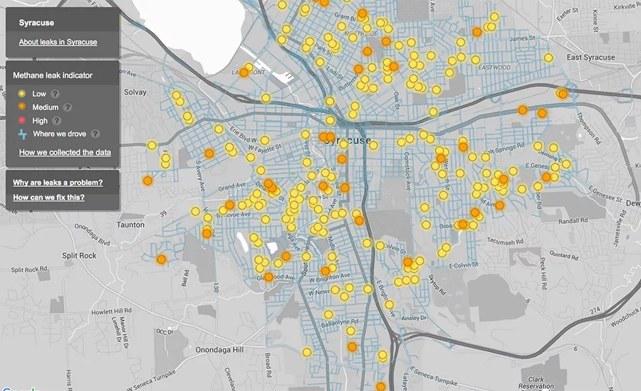
EDF maps of gas line systems tracks the routes driven by Google Maps vehicles and the locations of leaks detected, rated by severity. Pilot test map of Syracuse, above. Image courtesy of EDF/Google Maps
New Jersey’s largest utility, Public Service Electric & Gas Co., is the first gas utility in the nation to use methane emissions mapping data gathered by third party sources to help target natural gas mains for repair.
PSEW&G says it will use data gathered from mapping leaks in its service area by the Environmental Defense Fund, a non-profit environmental advocacy group. The utility will use the data to help prioritize replacement of 510 miles of gas mains and 38,000 service lines.
The gas line work is part of a three-year, $905-million infrastructure modernization program approved by The New Jersey Board of Public Utilities Commission Nov. 16.
EDF is mapping the leaks from gas utility lines—a significant contributor to the buildup of heat-trapping gases in the atmosphere—in cities around the country in partnership with Google and Colorado State University. The goal is to develop a method to quickly and cost-effectively detect, map, and quantify methane emissions from natural gas distribution systems. The project is developing data collection and analytical methods, including the use of gas-detection equipment on Google mapping cars, and a new algorithm for processing the data developed and tested at CSU over the last three years.
Jonathan Peress, EDF’s air policy director for natural gas, says “PSE&G is the first gas utility to provide extensive information to EDF on its existing gas system and on its method of targeting mains for replacement. The utility’s willingness and commitment to actively participate in our survey program enabled us to focus our work, so that PSE&G is able to use methane emissions data for its gas infrastructure upgrades.”
The utility’s program will accelerate modernization of its cast iron and unprotected steel gas infrastructure in 11 New Jersey counties. PSE&G will replace aging mains and service lines with plastic piping less likely to suffer from leaks or the release of methane gases.
EDF also has collaborated with Southern California Gas Co. and San Diego Gas & Electric in California, as well as Consolidated Edison in New York, which now publish web-based interactive maps that let the public see the location of leaks in their service areas. “This is a significant step forward for transparency in utilities’ leak management efforts, and we expect more utilities to follow suit,” says Anna Geismar, spokeswoman for EDF.
Geismar adds that maps reflecting the locations and relative sizes of leaks can improve regulatory oversight of the implementation of large-scale pipeline replacement efforts, by allowing “before” and “after” snapshots of the relevant service territory for comparison.
EDF has published online maps of gas main leaks detected by a pilot project of the system in Boston, Burlington, Vt., Chicago, Ill., parts of greater Los Angeles and Indianapolis, and New York’s Staten Island and Syracuse. It also is at work mapping leaks in three additional cities now.


