 |
| Front-end loaders on U.S. side reinforced stressed levees. (Photo courtesy of Rudy Gutierrez/El Paso Times) |
The summer's disastrous flooding in West Texas raised serious questions about whether traditional flood control systems are still viable. El Paso's rapid recent growth in private and public construction has been spurred in large part by expansions at the U.S. Army's nearby base at Ft. Bliss. This in turn put added strain on the city’s infrastructure and sparked debates about issues such as whether the city can handle the additional stress on its water, roads and other infrastructure and whether development on the city’s arroyos is a plus or a problem. The arroyos serve as natural runoff areas.
Perhaps of more immediate concern are issues surrounding the stability of the earthen dam, La Frontera Baja (also called La Montada), that spans the U.S.-Mexican border at the Rio Grande River. During the summer’s “Storm 2006,” as the flooding was called by the city and local media for lack of a better name, the 30-year-old earthen dam overfilled and threatened to deluge El Paso and her sister city, Ciudad Juarez.
“If the dam had burst, the city would have been inundated,” said Joe Gomez, executive vice president of the Associated General Contractors of El Paso.
While the dam held, the storm of 2006 caused damage to this westernmost Texas border town much like that inflicted by Hurricane Rita in southeastern Texas about the same time last year. Recognizing this, the federal government—urged by Gov. Rick Perry (R), Texas’ two U.S. senators and state Rep. Silvestre Reyes, D-El Paso—declared El Paso County a disaster area in mid-August.
 |
| Floodwaters claimed newly built video rental store. (Photo courtesy of Rudy Gutierrez/El Paso Times) |
Director R. David Paulson of the Federal Emergency Management Agency said the designation, authorized by President George W. Bush, can include grants to help pay for temporary housing, home repairs and other major damage caused by the storm. By late August, FEMA and the Texas Governor’s Division of Emergency Management had opened two disaster recovery centers to coordinate these efforts.
But this did not allay the concerns of private and public citizens about the strength of the city’s infrastructure and whether—in the event of another torrential downpour— the city had the ability to hold back floodwaters, keep La Montada from overflowing and provide adequate shelters to the low-income residents in the city’s low-lying lands.
“Most of the areas affected are lower-income areas,” said El Paso native Diana Sanchez, who works for a large clinical-lab-service firm. “The water drains that way.”
She added that a lot of people in the area don’t have flood insurance because of the expense and the perception that it is not needed.
The '06 storm forced the evacuation of thousands of residents and killed one TxDOT worker. Reyes estimated that the total for damages to the county could reach $250 million.
In late July, a dam safety hearing was held before a subcommittee of the House Transportation & Infrastructure Committee. “It’s interesting that emergency evacuation in El Paso occurred within days of a House subcommittee hearing on dam safety,” said Sarah Mayfield, spokesperson for the Association of State Dam Safety Officials, a national, nonprofit organization based in Lexington, Ky.
“Members of the subcommittee asked why the federal government should concern itself with nonfederal dams. Our president, Ken Smith, replied that dam failures in one state can affect another. The Juarez dam incident demonstrates the fact that there is also potential for international impacts.”
The Texas Commission on Environmental Quality, which oversees the state’s dam safety program, does not have jurisdiction over the Mexican dam. Still, just about everyone in the greater El Paso area was affected in some way, a spokesperson for the city said.
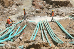 |
| Workers monitored pipes removing water from the endangered La Montada dam in Juárez. (Photo courtesy of Victor Calzada/El Paso Times) |
Currently, the U.S. Section of the International Boundary and Water Commission is reviewing the operation of its Upper Rio Grande Flood Control Project in the greater El Paso area. At American Dam, a USIBWC diversion dam near Asarco on El Paso’s west side, more than 8 inches of rain fell between July 29 and Aug. 5, including 4.5 inches on Aug. 1. The river’s peak flow registered 9,923 cu ft per second below American Dam on the afternoon of Aug. 1. By comparison, on the same date in 2005, the flow at that point was 177 cfs. The 2006 flood was the highest peak flow recorded in the river at the station below American Dam since 1958. “This was an unprecedented storm,” said Carlos Marin, acting commissioner of the USIBWC. “I am proud of commission employees for their efforts during the flood and I am pleased that our levee system worked as intended.”
During the flooding, Rio Grande water overflowed the banks of the low-flow channel and inundated the floodplain as the flood-control system is designed to perform. The USIBWC is reviewing its operations and data collected from the storms to consider improvements in the event of future floods. The commission said that improved coordination with the irrigation districts to control flows into the drains is one area requiring attention.
A congressional delegation has consulted with the USIBWC regarding proposed levee improvements to provide greater flood protection for interests along the river. “These floods were a wake-up call to many people who live in the desert,” Marin said. “It reminds us of the importance of supporting flood-control infrastructure in our community.”

Post a comment to this article
Report Abusive Comment