The National Oceanic and Atmospheric Administration is issuing an especially dire forecast for tropical storm activity in the Atlantic and Caribbean basins this hurricane season.
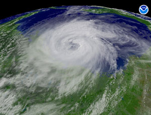
In a report released May 27, NOAA said that it is expecting “an active to extremely active” hurricane season.
For the six-month season, which begins June 1, NOAA is projecting a 70% probability of 14 to 23 named storms with top winds of 39 mph or higher.
It predicts the named storms will include eight to 14 hurricanes with top winds of 74 mph or higher, of which three to seven could be major hurricanes of Category 3, 4 or 5 with winds of 111 mph or more.
“If this outlook holds true, this season could be one of the more active on record,” says Jane Lubchenco, under secretary of commerce for oceans and atmosphere and NOAA administrator. “The greater likelihood of storms brings an increased risk of a landfall. In short, we urge everyone to be prepared.”
The report cites several atmospheric conditions that have been found to either discourage or encourage the development of Atlantic cyclones. Scientists have found them all trending toward encouraging the development of severe storms this year.
Those storm-fostering influences include high sea surface temperatures in the Atlantic and Caribbean—they are as much as 4º above average in some critical regions, and the apparent development of a Pacific atmospheric condition called La Niña, which suppresses upper-level westerly winds over the Atlantic that would break up storms by shearing their tops, if they were in play.
In addition, the current multi-decade cycle of high activity continues. Since 1995, the tropical multi-decadal signal has brought favorable ocean and atmospheric conditions in sync, leading to more active hurricane seasons. Eight of the last 15 seasons rank in the top ten for the most named storms, with 2005 in first place with 28 named storms.
“The main uncertainty in this outlook is how much above normal the season will be. Whether or not we approach the high end of the predicted ranges depends partly on whether or not La Niña develops this summer,” said Gerry Bell, lead seasonal hurricane forecaster at NOAA’s Climate Prediction Center. “At present we are in a neutral state, but conditions are becoming increasingly favorable for La Niña to develop.”
NOAA scientists will continue to monitor evolving conditions in the tropics and will issue an updated hurricane outlook in early August, just prior to what is historically the peak period for hurricane activity.


Post a comment to this article
Report Abusive Comment